
If you press certain Coordinate Numbers into a gps, you will find very special underground sections of Turkey
Cappadocia (Underground Cities)
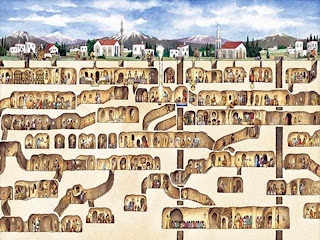
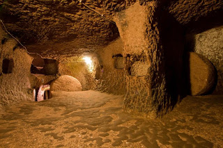
Located in Cappadocia, Derinkuyu is notable for its large multi-level underground city (Derinkuyu Underground City), which is a major tourist attraction. The historical region of Cappadocia, where Derinkuyu is situated, contains several historical underground cities, carved out of a unique geological formation. They are not generally occupied. Over 200 underground cities at least two levels deep have been discovered in the area between Kayseri and Nevşehir, with around 40 of those having at least three levels. The troglodyte cities at Derinkuyu and Kaymaklıare two of the best examples of underground dwellings.[wikipedia]Kaymaklı Underground City – 38.459893°, 34.751402°

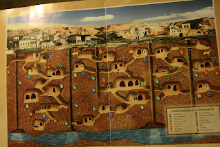
Kaymaklı Underground City is contained within the citadel of Kaymaklı in the Central Anatolia Region of Turkey. First opened to tourists in 1964, the village is about 19 km from Nevşehir, on the Nevşehir-Niğde road. The ancient name was Enegup. The houses in the village are constructed around the nearly one hundred tunnels of the underground city. The tunnels are still used today as storage areas, stables, and cellars. The underground city at Kaymaklı differs from Derinkuyu in terms of its structure and layout. The tunnels are lower, narrower, and more steeply inclined. Of the four floors open to tourists, each space is organized around ventilation shafts. This makes the design of each room or open space dependent on the availability of ventilation.[wikipedia]
Özkonak Underground City – 38.807168°, 34.840998°


Leave a Comment
You must be logged in to post a comment.