
Researchers develop a technique to identify communities most at risk for schistosomiasis.
Source: Interesting Engineering
With more than 200 million people suffering from schistosomiasis, a parasitic disease that is second only to malaria in terms of its health impact around the world, scientists have been working to come up with ways to identify hotspots for the disease.
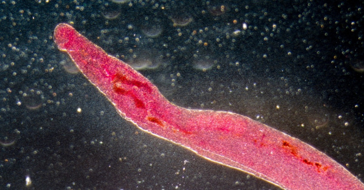
While schistosomiasis is treatable, the disease, which can cause bloody urine and stool, abdominal pain and damage to the liver, spleen, intestines, lungs, and bladder, is hard to eradicate from regions across the globe. Schistosomes, or the worms that cause the disease, grow within freshwater snails and multiple as they are released into rivers, lakes, and streams. People who swim, bathe or wade into the water can be infected by worms that penetrate the skin.
Snails to blame for schistosomiasis
A team of scientists led by the University of Washington and Standford University developed a technique that can help identify communities at most risk of getting this tropical disease. Their work was published in journal Proceedings of the National Academy of Sciences.
Relying on satellite images, drone photos, and Google Earth, the scientists studied more than 30 sites in northwestern Senegal, where villagers use the river and lake for bathing, swimming, washing clothes and cleaning dishes. It was the location of one of the biggest schistosomiasis outbreaks back in the middle of the 1980s.
The researchers counted and mapped the snails across the sites for more than two years. They also waded into the water to collect samples of mud and plants. Through their fieldwork they were able to demonstrate that the snails were distributed inconsistently with snails present in one location but then absent three months later. Realizing mapping the snails may not be the most effective way to identify areas at risk, they shifted their focus to the habitats where snails live. Armed with the knowledge that snails thrive in unrooted, floating vegetation that was captured by satellites and drones they shifted their focus to pinpoint areas rich in floating vegetation.
Automating identification
As a result of the work, public health agencies in Senegal can now look at aerial images to find areas that have the most floating vegetation and target those villages for treatment for the parasitic disease.
“Now we can take these aerial images season to season and have an idea of how the pathogenic landscape changes in time and space. This can give us a better idea of infection rates,” said co-author Giulio De Leo, a biology professor at Stanford University in a press release highlighting the work. “This project has been a tremendous effort and an example of collaborative research that would be impossible by a single person or a single lab.”
To make it even easier for agencies to use the information the team of researchers is applying machine learning to automate the identification of these floating vegetations in photos.
“We’re cautiously optimistic, but we still have some work to do to generalize our findings to new contexts,” said co-author Susanne Sokolow, a research scientist at Stanford University said in the same press release. “If, indeed, we find that the predictors for schistosomiasis are scalable and automatable, then we will have a powerful new tool in the fight against the disease, and one that fills a critical capacity gap: a way to efficiently target environmental interventions alongside human treatment to combat the disease.”
Source: Interesting Engineering


Leave a Comment
You must be logged in to post a comment.