
The vortex is teaming up with a record-breaking Arctic Oscillation to keep frigid weather at bay
Source: The Washington Post
January was freakishly mild across much of the Northern Hemisphere. Temperatures surged some 10 or more degrees above normal in parts of Europe, while the Earth as a whole took the top spot for its warmest January on record. The hemisphere set a record for the most unusually warm month of any month on record, dating back to the late 19th century.
Now one of the weather patterns behind the mild mid-latitudes, known as the Arctic Oscillation (AO), could approach or break a record this weekend — less than two weeks after shattering the previous benchmark. It comes as the polar vortex also nears record strength. This setup favors — but does not guarantee — a continuation of milder than average conditions.
The AO is an indicator of how easy it is for bitter cold Arctic air to charge south toward the mid-latitudes. When the AO is in its positive phase, winter’s characteristic polar chill tends to be bottled up within the confines of the Arctic Circle, leaving much of North America, Europe and Asia to be milder than average.
But when the AO goes negative, blasts of frigid air can pinch off from the polar vortex and advance to the south, affecting the Lower 48 states and Europe with winter’s icy wrath.

On Feb. 10, the Arctic Oscillation set a daily record value of 6.34, toppling the previous record of 5.91 from Feb. 26, 1990.
Yet a little more than a week later, the Arctic Oscillation could once again surge into record territory. It’s expected to peak in the 6.0 to 6.5 range this weekend, putting last week’s newly established record in jeopardy. Part of the pattern’s persistence and magnitude is derived from the infamous polar vortex, which itself is near record territory.
The polar vortex helps drive the AO

We’re used to blaming the polar vortex for winter’s icy kiss. But changes in the shape, structure and strength of the vortex can also lead to unusually mild winters across the mid-latitudes.
Andrea Lang, an associate professor of atmospheric sciences at the University of Albany, specializes in the dynamics of the atmosphere that play into the polar vortex’s evolution. In an interview, Lang said the polar vortex and the Arctic Oscillation are connected, despite being at drastically different altitudes (the first is a circulation of air several miles above the Arctic, while the AO is a pattern of surface air pressure).
This occurs because the atmosphere is interconnected, and subtle perturbations can have a cascading effect. Changes in the polar vortex high in the troposphere and lower stratosphere can have an effect at the planet’s surface, the fingerprint of which is often detected in the AO.
“There’s definitely an interaction there,” Lang said. “It doesn’t happen simultaneously. There’s a time lag.”
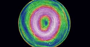
That interaction is particularly evident this winter, given the extreme doughnut shape and intensity of the polar vortex.
“The polar vortex is near daily record strength,” said Judah Cohen, the director of seasonal forecasting at Atmospheric and Environmental Research. “It’s very unusual to have a vortex this strong,” he said, noting that it’s comparable to the winter of 1975-1976.
“I think absolutely [the polar vortex and AO] are connected,” Cohen said. “The circulation in the troposphere and the surface AO tend to lag behind [changes in the stratospheric polar vortex] by about two weeks.”
In other words, a stout polar vortex — characterized by strong west-to-east winds in the upper troposphere and stratosphere circulating the Earth in a round, doughnut-like structure — can favor a positive AO. When the polar vortex becomes disrupted, and those west-to-east winds slacken, it’s more likely that the AO will shift negative and allow pockets of cold to spill south over the mid-latitudes.
How the polar vortex has been sparing us winter’s worst

The recent strength of the polar vortex, which began consolidating in mid- to late January, is contributing to the spikes in AO magnitude that have dominated in recent weeks, resulting in the comparatively tepid winter that persists over much of the eastern Lower 48 states and Western Europe.
January, for example, featured the highest averaged AO of any month since January 1993.
“There’s definitely an interaction there,” Lang said. “It doesn’t happen simultaneously. There’s a time lag.”
That interaction is particularly evident this winter, given the extreme doughnut shape and intensity of the polar vortex.
“The polar vortex is near daily record strength,” said Judah Cohen, the director of seasonal forecasting at Atmospheric and Environmental Research. “It’s very unusual to have a vortex this strong,” he said, noting that it’s comparable to the winter of 1975-1976.
“I think absolutely [the polar vortex and AO] are connected,” Cohen said. “The circulation in the troposphere and the surface AO tend to lag behind [changes in the stratospheric polar vortex] by about two weeks.”
In other words, a stout polar vortex — characterized by strong west-to-east winds in the upper troposphere and stratosphere circulating the Earth in a round, doughnut-like structure — can favor a positive AO. When the polar vortex becomes disrupted, and those west-to-east winds slacken, it’s more likely that the AO will shift negative and allow pockets of cold to spill south over the mid-latitudes.
How the polar vortex has been sparing us winter’s worst
The recent strength of the polar vortex, which began consolidating in mid- to late January, is contributing to the spikes in AO magnitude that have dominated in recent weeks, resulting in the comparatively tepid winter that persists over much of the eastern Lower 48 states and Western Europe.
January, for example, featured the highest averaged AO of any month since January 1993.
“Conditions have been conducive to allow the stratospheric polar vortex to become so strong that we’ve started to see the signal of this vortex come down,” Lang said.
Hannah Attard, an assistant professor at Embry-Riddle Aeronautical University, expects the polar vortex to remain impressively strong for some time to come.
“It’s so strong right now that even a disruption would just make it normal,” she said. That has also lead to a screaming west to east jet stream orbiting a low-pressure area above the North Pole, which contributed to a British Airways Boeing 747 setting a record for the fastest transatlantic flight earlier this month.
The bulk of any real frigid air has remained penned in over northern Siberia and the Arctic, as it was for virtually all of January. In the United States, it’s been a cakewalk of a winter east of the Mississippi River. Much of the East and Southeast is on pace for a Top 5 warmest winter on record.
How might this influence the rest of the season?
The polar vortex is anticipated to remain strong through late in the season. The stratospheric vortex ordinarily decays as temperatures warm in March or April.
“I don’t see anything that is suggestive of a significant [polar vortex] disruption,” Cohen said. That makes any long-lasting shots of intense cold over the Eastern United States unlikely, although more temporary cold snaps could occur.
“But even if we do get some cold, I don’t think it would be of any long duration,” Cohen said.
Attard has a similar view, but she cautions that Mother Nature’s caprices have taught us to think twice about turning our backs on winter.
“The main thing to keep in mind is that this is one aspect of the atmosphere that can influence cold air outbreaks,” she said. “There’s a lot more that goes into it, so we can’t put all our eggs in one basket. But we are seeing what we’d expect to see with a strong polar vortex and a positive AO.”
Since spring is just around the corner, the stratospheric polar vortex’s days are numbered. With daylight creeping back in the far north, the cold-core vortex will eventually weaken — and can break down rather suddenly.
That can lead to a wonkier, wavier jet stream in the mid-latitudes and unsettled periods of storminess across the Lower 48 states come spring.
Source: The Washington Post


Leave a Comment
You must be logged in to post a comment.