
Archaeologists believe 4,000-year-old engravings on Saint-Bélec Slab resemble topological features
Source: The Guardian
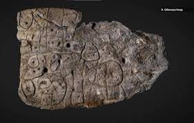
Archaeologists in France have uncovered a stone with 4,000-year-old etchings they believe may be the oldest three-dimensional map in Europe.
The engravings on the broken stone appear to resemble topographical features including hills and a river network.
More modern geolocalisation techniques suggest the 2.2-metre by 1.53-metre stone known as the Saint-Bélec Slab, first discovered in 1900 but then lost, show an area of western Brittany. It is believed to date from the early bronze age between 2150BC and 1600BC.
The slab was first found in 1900 during a dig at a prehistoric burial ground in Finistère by a local archaeologist, Paul du Châtellier, whose collection was bought by the National Antiquities Museum (MAN) in 1924.
Its whereabouts then remained forgotten until 2014 when it was rediscovered in a cellar under a moat at the museum’s chateau at Saint-Germain-en-Laye, north west of Paris.
Researchers, including some from Bournemouth University, are convinced the engravings on the stone represent the Odet River and its valley, and other lines show the region’s river network. Experts say the markings bear an 80% resemblance to an area around an 18-mile (29km) stretch of the Odet.
“Excavated in 1900 by Paul du Châtellier in a barrow (a mound of earth or stone raised over a burial ground) and forgotten for a century, this ornamental slab was recently rediscovered,” a spokesperson for the researchers said.
“Until the 1990s, the Saint-Bélec Slab was stored in a niche in the castle moat. Finally, in 2014, it was found in a cellar of the castle.
“It was the subject of a significant study that allowed it to be interpreted as the oldest cartographical representation of a known territory in Europe, a probable marker of the political power of a principality of the early bronze age.”
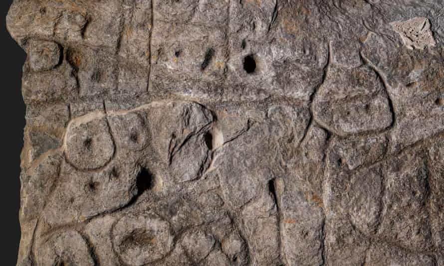
The slab is believed to have been used as one of the walls of a stone tomb. “It’s engraved face was turned towards the inside of the tomb, but its ends were hidden,” the researchers said.
“The presence of repeated motifs joined by lines gives this composition the appearance of a cartographic layout.”
To confirm their hypothesis, the researchers compared it with other, similar representations drawn from European prehistory and from other ethnic groups including Tuareg and Papuans.
“Since it is probably a mind map, some of the elements represented may be oversized, while their positioning is not necessarily in proportion to the distances that separate them,” the statement added, suggesting the slab highlights the mapping expertise of prehistoric societies.
“The Saint-Bélec Slab depicts the territory of a strongly hierarchical political entity that tightly controlled a territory in the early bronze age, and breaking it may have indicated condemnation and deconsecration. Burial and an iconoclastic act may thus have marked the end or the rejection of the elites who exercised their power over the society for several centuries during the early bronze age,” said the archaeological teams.
Source: The Guardian


Leave a Comment
You must be logged in to post a comment.